When I was doing research on public works for the Citizens for Dunwoody prior to the City being created, I realized that the City of Sandy Springs found a nifty research tool to analyze and map the city's infrastructure of streets. Compared to DeKalb County who used a road engineer to drive around to analyze and grade the streets from behind a windshield; the Sandy Springs system took all human input out of the equitation and gave a completely unbiased analysis. I saw the value in this tool and personally pushed that it be added to the City's year one budget. Once the laser vehicle completes the map of the Dunwoody's streets, the results will be published so that everyone can see what streets are rated the worst and from there a long term plan can be developed to improve our infrastructure.
The two systems described are listed below and in researching this post I just wanted to mention that I really enjoyed the City of Sandy Springs website and their electronic file repository. I hope that the City of Dunwoody website will someday be as comprehensive.
Sandy Springs
Sandy Springs pavement conditions map and long term planning.
DeKalb County
DeKalb Pavement Management System
2008 DeKalb Street Grades & my map of the worst in Dunwoody.
Below is the City of Dunwoody press release.
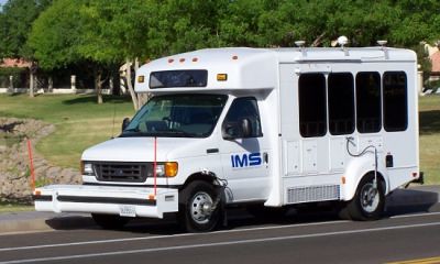
The City of Dunwoody, Public Works Department, has engaged the firm IMS, Infrastructure Management Services, to complete a surface distress survey on all public streets within Dunwoody. IMS will survey the city’s network of roads beginning tomorrow, August 28, with state of the art technology designed to collect data on various distresses found in the pavement infrastructure. The data collected over the next few weeks will assist the City of Dunwoody to develop long-term roadway rehabilitation plans and budgets.
The first phase will be to inventory and collect pavement performance data using a device known as a Road Surface Tester or RST. This device measures pavement roughness, rutting, cracking and other surface distresses as it travels down the roadway. The RTS vehicle will also be used to collect digital video and Global Positioning Satellite (GPS) information for cataloging pavement condition. The RST is a one-ton Ford van with four digital high-resolution cameras, GPS receivers, and a modified front bumper containing 11 lasers used to measure surface distresses. Operated by three field technicians, the RST travels at posted speed limits and will survey each roadway at least once. The RST then uses built-in software and on-board processors to develop roadway inventories, time code integration, and system monitors.
Once all the data is collected, it will be used to develop a series of reports allowing the city to cost effectively budget and plan for the long-term maintenance of the roadways.

1 comment:
I want one for DeKalb. Forget Google van! Nice bit of data gathering ...
Post a Comment