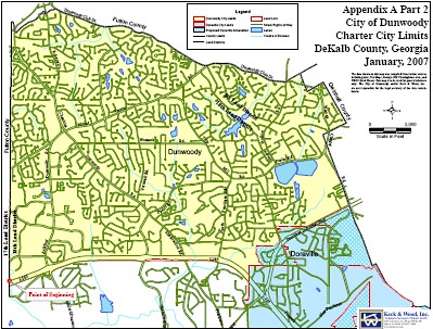
My server logs are telling me that a number of people are looking for maps of the City of Dunwoody, therefore I will list the maps that I have available for your viewing pleasure as well as provide the Boundaries for the City of Dunwoody.
Several years ago when I was assisting the Citizens for Dunwoody Committee in setting the city boundaries, I created a simple yet very effective online tool so I could view any property line in the new City of Dunwoody. Today the only change in my map from that time is the fact that the line for the city goes up to 285 instead of now encompassing it. Other than that change, the map is flawless.
- map-of-dunwoody-includes-tax-plat.html
- http://www.jkheneghan.com/city/map.htm
- individual plat_maps
- Voting_Districts_Dunwoody.pdf
- LEGAL_DESCRIPTION_of_Dunwoody.doc
- LEGAL Dunwoody District 1-2.doc
- LEGAL Dunwoody District 2-2.doc
- LEGAL Dunwoody District 3-2.doc
- Dunwoody_Aerial.pdf (Huge File 55 MB)
- Dunwoody_Resurfacing.pdf
- Dunwoody_Sidewalks.pdf
- Dunwoody_Signals.pdf
- Proposed Doraville Annex.pdf
- Proposed Chamblee Annex.pdf
Could the next map foreshadow the future boundaries of Dunwoody?
Future_Dunwoody.pdf

4 comments:
Both maps seem to include the portion of I-285 that abuts the city. What was the thinking behind that? It seems like it could be a problem with regard to public safety in Dunwoody.
Also if the new map were to take effect, it appears the Oasis would fall into Dunwoody. Is it likely to be grandfathered?
Well I wasn't officially on the board when the final decision was made but here were the reasons I remember hearing.
I-285 is going to under go a huge transformation in the next 15 years and having it within the city limits will give us a seat at the table for negotiations of entrances and exits.
If it was left as the northern most border of DeKalb police jurisdiction, police coverage of the highway could be spotty therefore Dunwoody would be called upon to handle accidents because we would be closer.
285 is the main east west access route for the south side of Dunwoody therefore our officers would be driving it on daily if not hourly basis.
I heard some saw it as a possible revenue stream but others saw it as a huge manpower drain therefore I know the decision wasn't an easy one.
What's the Oasis?
No clue on what would happen if it were to go to either Doraville or Dunwoody; feel free to speculate.
John,
The Oasis is a wealth redistribution center where men give their money to women.
The notion that we might be policing 285 if it were left in the county is a very weak argument--now we must police it. That a city employee uses 285 to perform their official duty is irrelevant. I expect the Dunwoody PD to use Fulton portions of Spalding as necessary to perform patrol and emergency duties. I do tend to agree with the manpower argument but I've discussed it with a neighbor who actually is on a police force. While addressing a sunshine-slowdown pileup on the top-end, who is patrolling our neighborhoods and business districts? Are we going to staff and tax for 'peak' demand? Keep in mind, most of the 285 wrecks serviced will not involve Dunwoody residents.
While I must say what you have reported about discussions concerning the 285 border decision is quite frightening, I find the City's intense desire to ban areola within Dunwoody downright hilarious.
Can citizens demand a reading of proposed ordinances? I'd love to watch a youtube of a red-faced mayor reading aloud in church an ordinance to "ban boobs". Maybe we could have a responsive reading and an Amen Choir?
Post a Comment