The City of Dunwoody will hold a Hotel Motel Tax Public Information meeting at 6:00 pm on November 15, 2017 at Dunwoody City Hall, 41 Perimeter Center East, Suite 103, Dunwoody, GA 30346.
Staff Recommends creating a Tourism Facility fund where 15% of Hotel Motel Tax increase would go to other tourism related projects not listed below and then 85% to funding Parks, Trails and Greenspace listed below in the proposed Priority List of Parks and Trail Projects. Once the revenue stream is confirmed stable (in about a year) there is a chance that the City could obtain a revenue bond whereby 10 years of funds could be received at once to fund the improvements listed and then the bonds would be paid via the new tax revenue stream.
• Perimeter Center East Park
• Ashford Dunwoody Trail – Phase I (Hammond Dr. to Perimeter Center West)
• Flyover Bridge Park
• Westside Connector Trail (MARTA Station to Ashford Dunwoody Rd.)
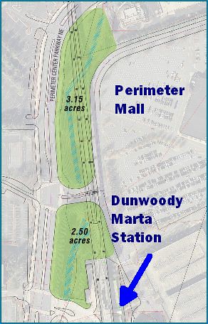
• Perimeter Park @ Dunwoody MARTA Station – North Phase
• Ashford Dunwoody Trail – Phase II (Perimeter Center West to Mount Vernon Rd.)
• Georgetown to Perimeter Trail (Perimeter Center East Park to Chamblee Dunwoody Rd.)
• Highstreet Trail (Central Parkway to Perimeter Center Parkway)
• Perimeter Mall Trail (Hammond Dr. to Perimeter Center West)
• Georgetown Gateway Trail (Georgetown Park to Cotillion Dr.)
• Ravinia Trail (Perimeter Center East Park to Ashford Dunwoody Road)
• Northfork Nancy Creek Trail – Phase I (Perimeter Center East Park to Valley View Road)
• Perimeter Park @ Dunwoody MARTA Station – South Phase I
• Northfork Nancy Creek Trail – Phase II (Valley View Rd. to Ashford Center Parkway)
• Winters Chapel Road Trail (Dunwoody Club Dr. to Peeler Road)
• Cotillion Trail (Chamblee Dunwoody Rd. to North Shallowford Rd.)
• Windwood Hollow Trail (Brookrun Park to Winters Chapel Road)
• Perimeter Park @ Dunwoody MARTA Station – South Phase II

1 comment:
Is there a map available that shows all of these prospective trails?
Post a Comment