Showing posts with label Map. Show all posts

Wednesday, June 4, 2025

FEMA Flood Zone review for City of Dunwoody based on City of Doraville project near Nancy Creek - very small negative impact expected near Tilly Mill.

Awhile back, Doraville constructed town homes along the flood plane of Nancy Creek directly adjacent to the City of Dunwoody and in doing so placed fill within the 100 year floodplain which may have negatively impacted Dunwoody single family residences (at the end of Vintage Lane), condos (Chateau at Dunwoody Condos) and businesses (Life Orthopedic & Spine Center) therefore I requested a formal study and the results came back negligible where the increase in flooding might be 1/10 th of a foot of flood water upstream near the Chateau Condos.  Downstream, near Vintage will not be impacted.

Here is the overview memo explaining circumstances with results and here is the raw data with maps.

Friday, September 30, 2016

Best GIS Maps of DeKalb and Dunwoody with linked Parcel & Zoning Information.

 Above was once the Best Map of Dunwoody - but much has changed!

Ten years ago when I was on the committee to help form the City of Dunwoody, I created an interactive map of all the County tax parcel maps and had them linked into one easy to find location.   Since then GIS has come a long way and I wanted to share some new tools for you.

I really like the new DeKalb County Map below as it is easy to use and will quickly zoom down to the parcel level to show you the tax information on each house.

http://maps.dekalbcountyga.gov/parcel/


Below is just one of many views within the City of Dunwoody's GIS system as it is very robust with complete Tax Bills linked into every property, flood maps, Council Districts, ect.   For more detailed information I use the Dunwoody site but if I want quick basic information I use the DeKalb site.

http://gis.dunwoodyga.gov/apps/smartmap/


Saturday, November 26, 2011

Peachtree Corners City Council registration starts Monday ends Wednesday.


The Charter for the City of Peachtree Corners was passed by the citizens and as shown in the links below they will only be providing very basic City services of Zoning, Code Enforcement, Building Permits and Solid Waste Disposal.  The City is broken up into three electoral districts whereby at least one council member will be living in the western district (light grey) closest to Dunwoody.   I look forward to working closely with whomever is elected to this position but (for selfish reasons?) my hope is that the person elected lives very close to Winters Chapel Rd and the Dunwoody border. 

If I was President of the Lockridge Forest Civic Association (one of the larger communities in the district) I would be looking for a local candidate to rally the community around.  Registration starts this Monday and ends Wednesday for the March election therefore the window of opportunity is very short.  Looking at the referendum results, this electoral district voted against incorporation but it still needs strong leadership to help guide the city on zoning matters specific to the area.

If anyone has interest in running for elected office and having the pleasure of starting a city from scratch but has questions, please feel free to call or reach out to me.  I may not be the best person on Peachtree Corners specifics but I am willing to assist you in researching the matter further.   Below are a few links and an article which describes the registration process.

City Fact Sheet from Peachtree Corners Yes, City Map with Voting Districts, City Charter

City Facebook Site, Another Facebook Site,


Qualifying Dates Set for Peachtree Corners Candidates (Patch)

Just a week has passed since Peachtree Corners voters have approved the referendum to incorporate as a city. Now it's time to look forward to electing the mayor and six council members who will be charged with running the new city.

Tuesday morning the Gwinnett County Board of Commissioners set the rate for candidates to qualify which will be three percent (3%) of the annual salary for the position they are seeking.  Tuesday afternoon the Gwinnett County Election's office announced that qualifying dates are "Monday, Nov. 28 and Tuesday, Nov. 29 and ending on Nov. 30 at 12 noon."

Lynn Ledford, the Elections Office Director said prospective candidates may come by the Elections office at 455 Grayson Highway, Suite 200, Lawrenceville between the hours of 9 a.m. and 4:30 p.m. to submit their qualification form and payment.

"Qualifying will be at our office and checks or money orders should be made payable to Gwinnett County BOC. We cannot accept credit or debit cards for payment," said Ledford.

For the mayorial race the cost to qualify will be $270 based on a $9,000 salary as stipulated in the city's charter. And it will cost $240 for anyone wishing to throw their hats in the ring for one of the six council members position, $8,000 salary.

Ledford said campaigning will begin shortly after the qualifying period is over as early voting begins Jan. 20, 2012, with March 6 set as Election Day.

For questions contact the Gwinnett County Elections Office at 678-226-7210.

Thursday, July 21, 2011

Dunwoody City Council Agenda for Mon July 25th

Monday, July 25th
Dunwoody City Hall
41 Perimeter Center East
Dunwoody, GA 30346
Voting Session at 7:00 p.m.
Watch Live

Voting Session Agenda & full city packet

Administer Oath of Office to Officer Michael Cheek.

Presentation of HERMES Creative Awards 2011 Platinum Winner for 2009 Comprehensive Annual Financial Report and 2011 Gold Winner for City of Dunwoody Website.

Citizen Police Academy Graduation.

SECOND READ: Ordinance to Amend Chapter 30, Traffic and Vehicles re: Designated Truck Routes.

Award of 2011 Capital Paving Contract.

PUBLIC HEARING & SECOND READ: Ordinance to Authorize a Special Land Use Permit to 4607 Brierwood Place (SLUP 11-061) to Initiate a Home Occupation for Private Educational Purposes with Customer Contact.

PUBLIC HEARING & SECOND READ: Revisions and Re-adoption of the City of Dunwoody City Code Chapter 27, Zoning, and All Previous Amendments Thereto.

PUBLIC HEARING & SECOND READ: Revisions and Re-Adoption of the City of Dunwoody Zoning Map, and All Previous Amendments Thereto.

PUBLIC HEARING & SECOND READ: Re-adoption of the City of Dunwoody Mayor and City Council Zoning Hearing Policy and Procedures.

Resolution to Regulate and Provide for the Calling of an Election to Determine the Issuance or Non-Issuance of the City of Dunwoody, Georgia General Obligation Bonds to Provide Monies for the Acquisition and Remediation of Certain Land for Parks and Greenspace.

Resolution to Regulate and Provide for the Calling of an Election to Determine the Issuance or Non-Issuance of the City of Dunwoody, Georgia General Bonds to Provide Monies for the Improvement to the Park System of the City of Dunwoody, Georgia.

Award of Government Services Contracts. & original RFP
  • Finance and Administration: JAT Consulting
  • Planning and Zoning: Clark Patterson Lee
  • Permits and Inspections: Clark Patterson Lee
  • Public Works: Clark Patterson Lee
  • Parks and Recreation: Clark Patterson Lee
  • Information Technology: InterDev
  • Public Relations/Marketing: Jacobs

Thursday, July 14, 2011

Dunwoody Zoning Map


Above shows the area around Dunwoody Village and I would ask anyone of interest to please download and review the full map, looking for possible errors. The data was compiled from DeKalb County tax and zoning records and I (the City Council) is being asked to certify that it is correct.

When the pdf document loads, please zoom in to about 100% to see the full details.

Does anyone see any issues or errors?  Thanks.

Monday, January 31, 2011

Best Map of Dunwoody includes all Property Lines.

Best Map of Dunwoody - Tax Plat Property Line Tool

Several years ago when I was assisting the Citizens for Dunwoody Committee in setting the boundaries, I created a simple yet very effective online tool so I could view any property line in the new City of Dunwoody. Today the only change in my map from that time is the fact that the line for the city goes up to 285 instead of now encompassing it. Other than that change, the map is flawless.

Click on the photo above or this link and allow the slightly over sized map to appear. Once the map is up, scroll the the map over or down if needed in order to find your house or an area that you are familiar with. Then click that location on the map.

From there a pdf tax plat map of the area will load showing what you just clicked, including possibly your house. Zoom in on the pdf and from there you can read every subdivision name, every street, every property line including the length of each line and the total acreage on large parcels.


Still to this day I find myself using this tool for various items that cross my desk and figured I would post it again (originally posted August 4, 2008). Give it a try.

Thursday, February 26, 2009

DeKalb Public School enrollment will it be up or down and how will it affect Dunwoody? What about Bus service?


Will DeKalb's School Enrollment be going up?

http://www.youtube.com/watch?v=GhsYKn4Jnyo

Every DeKalb County Public School in Dunwoody has portable classroom trailers and when the new fourth & fifth grade school opens next year on Womack, many of those trailers will remain in place. I am seeing conflicting stories in the news regarding school funding, school closures and whether enrollment will be going up or down. The DeKalb County School Board is thinking about closing more schools and increasing the busing distance to reduce costs. Now because of economic hardship it appears that many families who have sent their children off to private school in the past are deciding to return to the local public schools.

Today I read on the DeKalb County School Watch blog that the newly built Arabia Mountain High School which was scheduled to be a neighborhood school as well as being able to accept transfers from other nearby "failing" schools has been modified to be Magnet or "Choice" school which wouldn't have to accept transfers from other schools. This change directly affects Dunwoody High School since it will still be a "receiving" school from students all over the county. If this is true, it sounds like a bait and switch to me in order to prepare a justification of the next SPLOST tax for Education.

Finally a school issue which will be affecting all of Dunwoody (even if you do not have children in school) is the yet to be finalized busing plan for the new school. With elementary school children from all over Dunwoody going to this school and with a mix of K though 3 as well as the 4 & 5's on the same pick up route; it will be a logistical nightmare to work a feasible and efficient schedule for all involved.

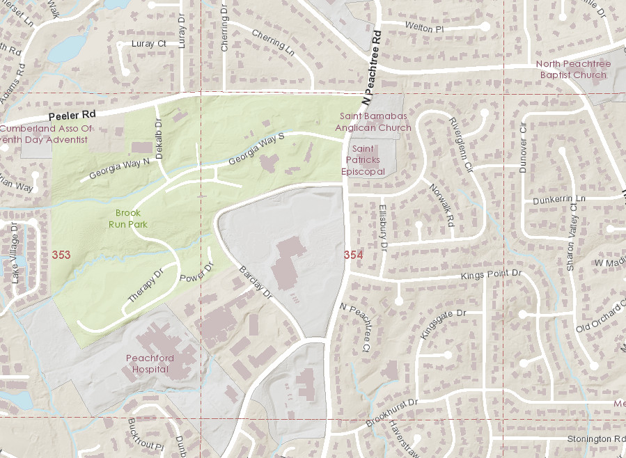
On top of that, Dr. Crawford Lewis has proposed that 
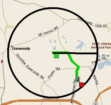
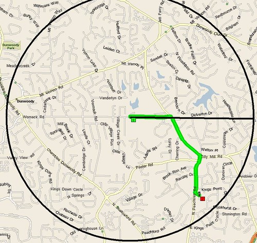
the walk zone be increased from 1 mile to 1.5 miles - as student safety and traffic conditions allow. I had my GIS software draw a 1.5 mile circle around the new school which is as the crow flies and then I mapped the walking distance from the school to my home, which measured 1.6 miles. Even if my fourth grader is offered a bus to the new school, we will have to decide if the logistical circumstances make sense for us to accept the ride.

The prospect of very early bus pickups for those who will still be offered the bus and the 1.5 mile walking distance without buses being offered, means that there will probably be a lot of cars making round trip visits to Womack Road come early August.


The job of putting together the transportation plan for the new school to best serve the needs of the students will be very difficult and I hope that the school system explores every option to find what is best for the students. This is what the new school website says regarding school start times and transportation logistics.

What time will school start and end?
  • This is still under review. The current plan on the table has students delivered to the Academy starting at 7:00 am. Once the Academy students are dropped off, the bus will continue its route to the next elementary school. Students will be picked up from the Academy at 2:00 in the afternoon. Academy will dismiss at 2:00 pm. Buses will leave the Academy and go to Austin, Vanderlyn, and Chestnut Elementary schools before delivering to the neighborhoods. This is subject to change if the school release time is modified. This will create an earlier time for pick up in the morning, but the afternoon pickup and drop off time will be the same and the students will arrive home at the same time as their siblings.
How will the buses run, in relation to the current busing schedule?
  • We are an elementary school, and therefore, we will work around the established elementary start and end times with some flexibility. This is a transportation issue that the DeKalb County School System is looking into to determine the best possible time.
Whether or not you have children in the DeKalb County School System, these school items affect our tax bill, our home values and our overall quality of life and I thought they should be brought to your attention. I know that I will be watching closely.

Thursday, December 11, 2008

Map of Dunwoody & City Boundaries


My server logs are telling me that a number of people are looking for maps of the City of Dunwoody, therefore I will list the maps that I have available for your viewing pleasure as well as provide the Boundaries for the City of Dunwoody.

Several years ago when I was assisting the Citizens for Dunwoody Committee in setting the city boundaries, I created a simple yet very effective online tool so I could view any property line in the new City of Dunwoody. Today the only change in my map from that time is the fact that the line for the city goes up to 285 instead of now encompassing it. Other than that change, the map is flawless.
The good folks over in Doraville experienced a messed up election for the annexation for the property between our two cities and the matter is now in the courts. During the legislative process we had to be prepared to take those properties in case Doraville or the State demanded that we do so, therefore the following map was prepared, but never expected to be used. Since DeKalb may not want to serve the area in future when Dunwoody is completely up and running; there is a slight chance that the State may mandate that it be serviced by one of the existing cities.

Could the next map foreshadow the future boundaries of Dunwoody?

Future_Dunwoody.pdf

Monday, August 4, 2008

Best Map of Dunwoody includes Tax Plat Tool to view all Property Lines.

Best Map of Dunwoody - Tax Plat Property Line Tool

Two years ago when I was assisting the Citizens for Dunwoody Committee in setting the boundaries, I created a simple yet very effective online tool so I could view any property line in the new City of Dunwoody. Today the only change in my map from that time is the fact that the line for the city goes up to 285 instead of now encompassing it. Other than that change, the map is flawless.

Click on the photo above or this link and allow the slightly over sized map to appear. Once the map is up, scroll the the map over or down if needed in order to find your house or an area that you are familiar with. Then click that location on the map.

From there a pdf tax plat map of the area will load showing what you just clicked, including possibly your house. Zoom in on the pdf and from there you can read every subdivision name, every street, every property line including the length of each line and the total acreage on large parcels.


Still to this day I find myself using this tool for various items that cross my desk and figured that now that the city is officially going to happen that this should be shared. Give it a try.